My second semester is done at SUSOM, and I’m navigating through third. This post will discuss my break; I’ll have another about my academics. The break after second semester alleviated a significant amount of social stress; after two or so years of our dating, my girlfriend finally met my family. The break was thoroughly enjoyable as well –it was the first time in 8 months that I got to see my family again, and for the first week we went hiking in the state or Arizona, which in itself became fairly eventful.
We landed in Phoenix and were hosted by my mother’s close friends – very generous and kind. Additionally, many of my questions about rotations were partially answered – our host had also attended a Caribbean medical school and was now responsible for a flourishing family medicine practice.
Our first hikes were in Sedona, AZ. We trekked both Devil’s Bridge and Cathedral Rock – I’ve put the spectacular views below. From Sedona, we went to the Grand Canyon, which I found a bit underwhelming in terms of fun after Sedona.

Devil’s Bridge in Sedona, AZ

Cathedral Rock in Sedona, AZ
After surveying the canyon for two days, we drove back to Phoenix and stayed with our hosts in preparation for the strenuous hike the next day.

Grand Canyon, south rim
Chiricahua National Monument
We started auspiciously at an early 7am from Gilbert, AZ and arrived at 11am at the visitor’s office with the intention of completing the full 8.5 miles “big loop trail” by sundown. The trailhead was about 6 miles from the ranger’s station. We started hiking about 11:30am.
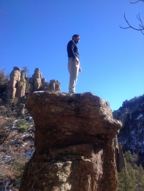
Climbing a spire; sweatpants required
The primordial rock formations were captivating, and the whole area had been sprinkled with snow. Our leisurely pace brought us to the Heart of Rocks around 5pm, and at this point we realized our pace was not going to allow us to make it back to the trailhead (where my dad was waiting) before the lights went out and the flecked sky became our scene. After the heart of rocks, we made it double time and came to a fork in the road. We had about 30 minutes of light left, and we could choose either to go (1) 2.8 miles with an inclining, circuitous road to the trailhead where my dad was waiting or (2) 1.5 miles to the visitor’s center with a descending, straight path and figure out what to do from there, knowing that the place closed at 4pm.

Spires at Chiricahua National Monument
Compounding all of this was an absolute lack of cell phone signal. We chose to go to the ranger station, and as we did, the soft, dusty dusk that painted the stone spires pink and orange waned to velvet black. Using cell phone lights as guides, we navigated in the dark to the ranger station-welcome center and were simply happy to have made it. However, we still had no way of contacting my dad, who was anxiously waiting for his entire family to emerge from the darkness of a 8 miles hike and whole 6 miles away.

Snow, Chiricahua National Monument
To our surprise, there was a pay phone outside the center, and, to our even greater surprise, we had the exact change needed to make a call. We really had 3 options at that point – call for help, stay at the center overnight, or hike to my dad along a paved road for cars that would take us to our original trailhead. We decided on the third option. As a precaution, I called my dad (who had no signal) and left him a message of our plan. There was no other way for him to leave the park without running into us – it was really a matter of hiking another 6 miles after an entire day’s worth of hiking.
So, heads down, bundled up, we trekked, leaving the park center at around 6:30p. Chiricahua National Monument is well known for its night sky, and we were dazzled by the display; the lack of light pollution and isolation of the park makes it an ideal spot for looking at the star-strewn sky. However, we were not in the highest of spirits, but nonetheless, we kept going and appreciated it.
Eventually, we came across a few signs and markers to let us know exactly where we were in terms of progress. There were lit with my brother’s iPhone and I marked them on our map. We then came across three lights immediately adjacent to the road. I was not really sure what they were but, as we approached I realized we were looking at three people, all of whom had some sort of light attached to their headgear. We were saved. They had a truck, too.
My first question was something like, “what are you guys doing out here?” and then something like “oh that’s cool do you mind helping us out?”
Turns out, the group were park rangers themselves – in fact, they recognized us from the trail earlier that morning. One of them volunteered to drive us back to the trailhead where we hoped my dad would be waiting. My brother and I hopped in the back of the pickup and my mother ride in the passenger’s seat and related our story with the ranger. We were relieved to see Dad in the otherwise deserted parking lot. Elated to see us, he exchanged his ordeal of being frightened to death, and we exchanged stories. The park ranger (whose name was Jason) led us out the park and we were gracious for his help.
SO, we’re leaving the park and life is good. We hiked, had a story to tell, etc. We’re driving in the middle of nowhere, starving, and a car drives past us in the other direction. My dad makes some off-handed comment like “I wonder what that car is doing out here” and then not 5 minutes pass before it has turned around, lights flashing, and it’s pulling us over. Turns out, that road that we were on is notorious for drug and human trafficking, and in the span of the next 10 minutes 2 other cop cars and a border patrol car also pull up. After the entire hiking incident, that bit is the icing on the cake for that day. My dad gets his citizenship checked (because we’re brown, of course, and in AZ) and a warning or something.
Well, at this point, it’s too late to make it back to Phoenix, so we book a small hotel right off the interstate with my dad’s phone, pick up some pizza, and call it a night.
Overall, an awesome, unforgettable day. The map of our trail is below. Blue is what we intended, red is what we hiked, and green is where we were driven by the ranger.

After the AZ trip
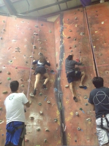
Climbing with Amanda, Parth (brother), and Adarsh (Dr. Samuel’s son)
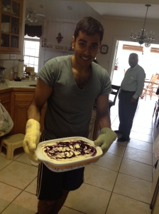
Blueberries :0
My girlfriend (Amanda) flew into town and we had various adventures: rock climbing in Lafayette, LA, getting a pedicure with my cousin Amar (with whom I caught up, too – it had been forever since I had seen him), ice skating (my first time – I didn’t fall), making blueberry cheesecake, showing her the downtown portion of BR, seeing Frozen, getting froyo from Yogurtland, and working out. On the last note, I hit several PRs and they are logged in my workout journal. I was happy about that, too. I also caught up with my friends at NuPotential, Dr. Brylinski at LSU, and Dr. Samuel, who enjoyed the cheesecake I made.
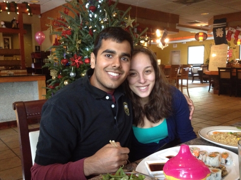
AAD and AMK – Sushi with Amar
